
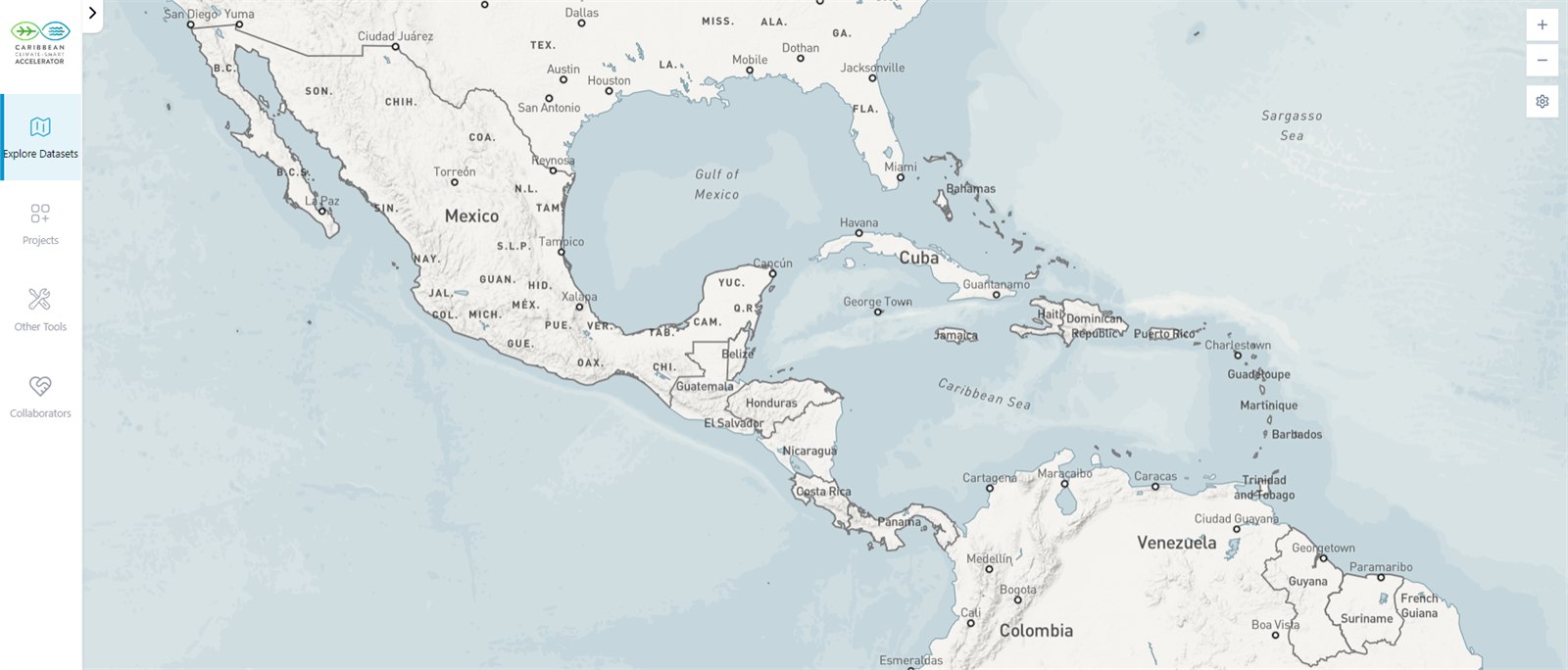
Climate Smart Map
The Climate Smart Map is a comprehensive, interactive open-data platform designed to drive climate action across the Caribbean by providing a shared source of truth for philanthropists, policymakers, investors, and entrepreneurs. Launched at COP28, this living tool aggregates regional climate insights, alongside demographic regional data to enable strategic decision-making and efficient investment.
The Caribbean Climate Smart Map is Live, Free & Open
About the Climate Smart Map
Built to empower everyone from philanthropists and investors to heads of government and entrepreneurs to make smarter, faster, more impactful decisions.
The Climate Smart Map is the Caribbean's most comprehensive interactive open data platform for climate action data, built to empower everyone from philanthropists and investors to heads of government and entrepreneurs to make smarter, faster, more impactful decisions.
Launched in Dubai at COP28 in December 2023, the Climate Smart Map consolidates climate insights and demographic data from Caribbean nations into one intuitive, accessible platform.
It is not a report. It is not a snapshot. It is a living, openly accessible tool, designed to evolve as new information becomes available, including through crowdsourced contributions, and to turn information into action.
It provides policymakers, investors, project developers, entrepreneurs, NGOs, philanthropists, and advocates across the region with a shared database. One that shows not just where the challenges are, but where the opportunities are too.
A Collaborative, Crowdsourced Living Tool
The map is a collaborative tool that grows stronger and more valuable as data is contributed. Communities, organisations, and practitioners across the region can submit data directly to the map. This creates a crowdsourced layer to the map that grows with the Caribbean's climate story. All submissions are verified before going live, ensuring the platform remains a trusted source, comparing similar information, for everyone who relies on it.
Who the Map Empowers
Policymakers & Leaders
Pinpoint national resilience baselines, monitor progress toward Paris Agreement commitments, and allocate public capital to priority vulnerabilities.
Investors & Financiers
Discover a vetted pipeline of bankable climate-smart projects across renewable energy, circular economy, and marine resilience ready for capital.
Entrepreneurs & Developers
Access regional benchmarks, connect with funding partners, and spotlight homegrown innovations on a pan-Caribbean stage.
Philanthropists & NGOs
Direct catalytic grant funding and technical assistance to high-need communities where intervention yields maximum measurable impact.
Open Data Standards
Rigorous validation before publication
- Pan-Caribbean baseline comparability
- Demographic and environmental overlay
- Independent regional and international sources
Why It Matters
The Caribbean does not have the luxury of imprecision. Every dollar of climate finance must be deployed where it yields maximum impact.
< 1%
The Caribbean accounts for less than 1% of global carbon emissions.
~40%
The cost of climate-related damage to the region represents close to 40% of total global losses.
> 225%
For some countries, a single weather event has caused losses exceeding 225% of national GDP.
That disparity between contribution and consequence is precisely why data matters so much here. The Caribbean does not have the luxury of imprecision. Every dollar of climate finance, every policy decision, every infrastructure investment needs to go exactly where it will have the greatest impact.
The Climate Smart Map makes that possible.
By translating complex spatial data, regional indicators, and local vulnerability assessments into clear, actionable intelligence, the platform bridges the gap between high-level ambition and capital allocation on the ground.
“The map is a guiding force, steering us towards strategic climate action — directing climate finance to areas where it yields maximum impact.”
Racquel Moses
CEO, Caribbean Climate-Smart Accelerator & UNFCCC Global Ambassador
Remarks delivered at COP28 Map Launch, CARICOM Pavilion
What It Supports
Connecting climate-smart projects with the capital, partners, and data needed to move them from idea to implementation.
Mobilizing Climate Finance
The Climate Smart Map is a central part of CCSA’s mission to mobilize climate finance. It gives investors transparent visibility into bankable opportunities across all Caribbean territories.
Idea to Implementation
It connects climate-smart projects with the capital, partners, and data needed to move them from idea to implementation, helping unlock funding and financing across the region.
Unlocking Regional Pipelines
By consolidating national targets, NDC commitments, and feasibility profiles, the map creates regional aggregation that attracts multilateral and private capital at scale.
Who Built It
The Climate Smart Map was developed in collaboration with Templeton World Charity Foundation, PwC Trinidad and Tobago, and Vizzuality and launched on the world stage at the CARICOM Pavilion at COP28.
Templeton World Charity Foundation
Catalytic donor supporting open science, regional data empowerment, and systemic resilience solutions across the Caribbean.
PwC Trinidad and Tobago
Providing institutional data rigor, baseline verification frameworks, and strategic governance to ensure trusted metrics.
Vizzuality
World-class geospatial engineering and interactive user experience design turning complex environmental data into intuitive action.

Explore the Climate Smart Map
The Climate Smart Map is live, free, and open to anyone who wants to understand, add to, and act on the Caribbean's climate moment.
Access the interactive map to explore regional baselines, pipeline projects, and investment opportunities across 26+ nations.
Explore the Climate Smart MapHave project data to contribute? Submit Data or Project.